Forming an invisible backbone for Chicago’s streets and property lines is a little known system called the Public Land Survey System. In 1783, along with the thirteen original colonies, the newly formed United States acquired new territories stretching to the Mississippi River.
Congress passed a law called the Land Ordinance of 1785 providing for surveying the area from Ohio to Minnesota including Illinois. The Northwest Ordinance of 1787 provided for government of this new territory—officially called the “Territory Northwest of the River Ohio.” In later years the area was called the Northwest or the Old Northwest.
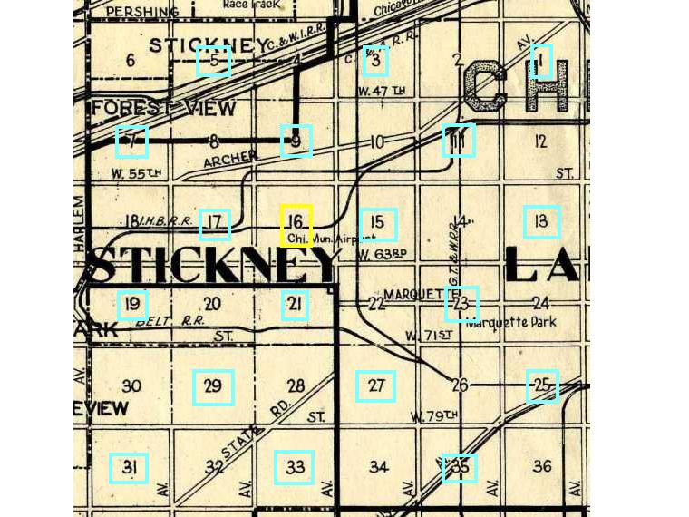
The purpose of the survey was to gain money through land sales and to give land for education and to war veterans as a pension. The territory was divided into six mile by six mile areas called townships. Each township was then divided into 36 one mile by one mile areas called “sections.” Thus each section is one square mile or 640 acres.
Usually land was sold or given away in some multiple of 160 acres. 160 acres, also known as a quarter section, is ½ mile by ½ mile or about the size of Humboldt Park.
The surveyors would survey the outside lines of each section, making notes of the vegetation and water boundaries, and then marking each section corner and often the half section points as well. Thus they literally visited each square mile of Illinois. Survey notes form a valuable record of early vegetation and geography. The Morton Arboretum has a page about pre-settlement vegetation of the Chicago area based on surveyors' notes.
The National Map has a more detailed description and explanation of the Public Land Survey. The History of the Rectangular Survey System (47mb), opens a new window is extremely detailed. We also have the History of the Rectangular Survey System in our Government Publications Department.
The federal government gave land to the states to benefit the schools and transportation improvements such as canals and railroads. In Chicago’s case, half of the square mile sections within five miles of the canal were given to the Illinois and Michigan Canal Commissioners for sale. Section number 16 of each township was devoted to the public schools.
An example is the square mile school section Midway Airport sits on. The section was apparently little used for the first 100 years. Then in 1926 the Board of Education leased 600 acres to the City for use as Municipal Airport. Ten acres were reserved for Hale Elementary School. The school remained at the end of the runway of what became the world’s busiest airport until 1953. Finally in 1981, the school board sold the land to the city.


Add a comment to: Public Land Survey: Technology That Changed Chicago